*Review of the Garmin Vista C*
I will address several things in this review of the Garmin Vista C. The unit and the manufactures details may be seen here. http://www.garmin.com/products/etrexVistac/
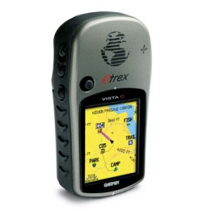
Look & Feel - I have found this GPS to be pleasant to look at and comfortable to hold. It fits very well within your hand, and unless you have bear paws, it is also not too small.
The color screen is actually very nice to have. I have found that it defiantly enhances the maps and the directions the GPS gives by highlighting the route with a different color then the rest of the map.
Another nice feature that goes with the color is that at sunset, the GPS knows when sunset will be for the area it is in, the color scheme changes. This makes it easier to see in the lower light situation. The unit also provides backlighting at two separate levels. The lighting automatically comes one whenever you touch one of the buttons.
Features - The features seem to be endless. This GPS is geared for everyone from the traveler, hiking, fisherman, hunter… even for those crazy folks who jump out of perfectly good airplanes. The unit will track your speed, tell you your average moving speed, and about any other thing you can think of regards travel info.
This GPS has a built in compass. But before you throw away your handy GI compass, remember, you need batteries to run this one. The unit also has a barometric altimeter.
One of the great features is the auto mapping. With the base map it is difficult to get super detailed directions to a specific spot. But the general directions have proved quite accurate. You can indicate that you want to go the shortest route - it will tell you shortest distance… or you can choose shortest time. I have no idea how the unit can determine this. You can also indicate what kinds of routes you want to take or avoid. Ie - toll booths, highways, etc. You may also indicate what kind of vehicle you are using. This supposedly effects the route it may choose for you as well. Now, as I mentioned, the base map is pretty limited. I do not believe, from my use, that any of these features I mentioned really make a difference if all you are using is the basemap. The base map will get you from city to city, but not to your friend Jimmy’s house… unless you have the coordinates and just follow the compass… it will not give you this kind of detailed turn by turn directions without upgrading your software.
The software of choices for this unit are numerous. You can pick up the topo map, maps of national parks and various others. If you want real details that cover most everything and includes the ability to use the automap feature, Garmin says to purchase City Select North America v. 7. The average price for this software is $120. But remember, it includes detailed maps and information for all of North America. I was unable to purchase City Select and was told by the folks at my friend local (6 hrs away) REI that the software to use was City Navigator North America v. 7. So, I bought it. It works extremely well. I tried several different locations and it gave great directions to each. It is very detailed in its turn by turn directions, almost to the point of being irriating. Still very accurate information.
Also, a huge question is always about the batteries. I did not just want to tell you want the company said, they give you 20 hours of use on a fresh set of batteries (2AA). I found this to be conservative. Obviously it is dependent on your usage, if you play games the whole time you have it on (who plays games on a GPS) your batteries are going you run down fast. However, if you use it for directions and finding information about your area using the City Navigator, you can expect more then the 20 hours. I have been through 4 sets of batteries so far and found that the average is around 25. I did have one set last for 30 plus, but it would not turn on the backlight at a certain point… but he GPS was still giving me directions.
The downsides of this unit. The memory is 24 M of memory… no more, no less. There is no expandability. Now, if you plan to use only the base map or don’t mind doing regular uploads from you computer, it will be great. But I found this to be very frustrating. The maps are divided into sections with City Navigator, unfortunately there is no average map size. For example, you could probably get most all of Canada and Alaska in 24 M, which is several map areas. But the area for New York city is so big you could not get that on the unit at all, with the map area coming in at around 28 M.
Overall this I think this is a good unit. It is user friendly, gives good and accurate information, and provides loads of information for your consumption. The truth is that I can only think of the one downside I outlined above. If you are happy with the limited memory and don’t believe you need more, this GPS is for you. If you want to have more information in your GPS without having to reconnect to your computer, this one is not for you.
hickory
www.alpharubicon.com
All materials at this site not otherwise credited are Copyright © 1996 - 2006 Trip Williams. All rights reserved. May be reproduced for personal use only. Use of any material contained herein is subject to stated terms or written permission.