*RSAR, Mission One*
Search For Missing Jones Gap State Park Hiker Continues
Search Enters Third Day
UPDATED: 4:19 pm EST November 15, 2004
GREENVILLE, S.C. Channel 7 News-- The search for a missing man continues in Jones Gap State Park on Monday.
Searchers were back in the park at 7 a.m. to look for Joe Mancino, who has been missing in the park since Saturday. Teams of searchers are working along the park's trails and paths, as well as any areas where Mancino may have drifted into while walking.
Teams are following clues as small as footprints found in unexpected areas.
"If a person is walking, he's going to leave some type of clue whether it be a footprint, candy wrapper or something, and to not find anything at this time is really frustrating for us," Ranger Joe Hambright said.
Rubicon Search And Rescue - Mission one
As you know, The Rubicon also runs "Rubicon Search And Rescue (RSAR) and is a member of the "National Association of Search And Rescue" (NASAR). The South Carolina chapter had it's first "Real world" test today.
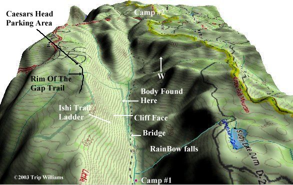
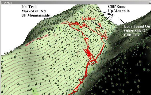
There's just too much to tell, but Saturday a 75 year old man went hiking with a group from Furman (all senior citizens).. Jones gap has opened a new trail call "Ishi Trail" And it's not rated by difficulty yet.. the trail is the worst I have hiked in YEARS.. at one point you literally have to climb a big wooden ladder.. the whole trail is either straight up, or straight down, lots of cliffs, lots of narrow spots on the trail to slip and fall 100's of feet.. As you'll see farther below, we traversed over 1000 feet of STEEP grade, up and down, several times.
The Group from Furman admits that they didn't know what they were getting into.. About 3 miles in at the first ladder Joe couldn't go any further (Everyone is AMAZED that a group of senior citizens made it THAT far, this is ROUGH terrain).
He told the rest to go on, he was going back.. they left him sitting there... no one has seen him since.
This guy has a LOT of enemies.. which I won't go into detail about, but it does make the mission harder when there may be foul play involved.
They sent us out in teams of 4... one Park Ranger, Two SAR members, one medic... Carrie is a Paramedic and NASAR certified, and I'm NASAR certified, so we got to stay together, and we went out with a Park Ranger and a fellow NASAR member.. almost every Searcher out there is a member of the group that sponsors us (NASAR).. Lots of NASAR gear and patches, etc, everywhere.. It felt like we were in a club.. people saw the NASAR Card and you were suddenly "one of the group"
Let me say here that the Victim has been out there three days, and it's been down to freezing at night, he was only wearing a light jacket, so it's now a "Search and Recovery" mission.. meaning he's most likely dead.. if he fell off a cliff (Easy to do out there) or broke his leg, he wouldn't have survived this long. He may have even covered himself with leaves to try to keep warm, and died, making him that much harder to find.
Helicopters everywhere, TV news choppers, police choppers, volunteer pilots in private choppers.. It was a circus... We got issued county radios and They sent us on the trail where he was last seen, to run a grid on it (WE got slated for that trail.. it's where EVERYONE wanted to be, but since Carrie is a County paramedic AND NASAR certified, and I'm NASAR certified and the other guy (Kevin) was NASAR Certified, we got the premo search area). The Park Ranger that made the statement to the press at the beginning of this article was with us on our search grid.
Let me brag on the Garmin E-map a bit.. We'd have been SCREWED without it several times... It's in a narrow valley so it starts getting dark at 3:30.. and it found THE one gap in a wash that didn't end as cliff... Otherwise we would still be out there on our hands and knees trying to get back up the mountain COVERED in dense mountain laurels.
We covered 7.5 GRUELING miles... that doesn't sound like a lot, but you have to remember, this ain't on cushy trails, this is cross country, rocky, mountainous area, straight up and straight down... NASTY.
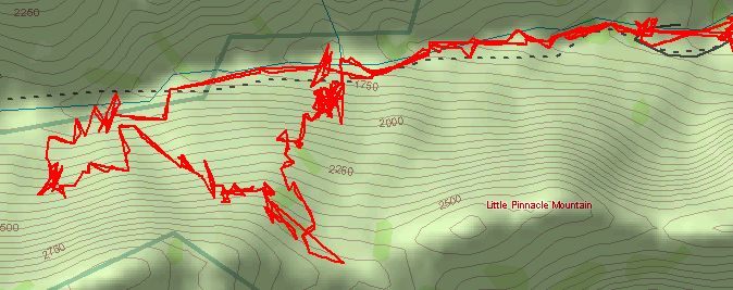
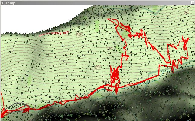
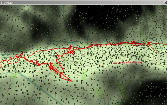
When our team got back in after our 8 hours (They only allow a team to be out 8 hours) the SAR Control center was downloading GPS tracks using their Garmin E-trex units.. I told them they could have our track from the E-map.. their software connected right up to the E-map GPS and downloaded our tracks.. they got a CROWD of the SAR people in there to look at the detail from the E-map... Everyone else's tracks just looked like straight lines and boxes.. but the E-map maps every jiggle in the trail... We were "Team 5" and we covered the most Area of any group out there so far... they downloaded our Trail track from the E-map, along with the GPS information from other teams, onto a topomap of the area and it gives you get an EXCELLENT picture of what areas have been searched, and how well they have been searched... their software plots every team's tracks when they get back in.. The National Forest service software is VERY similar to the TopoUSA software I used to make the pictures above. The National Forest Service Uses Garmin equipment, and I showed them today how to make just about any Garmin Unit work with their software (They thought only the Garmin e-trex would work with it, Not so).
The SAR Dogs are INCREDIBLE.. the handlers (there were MANY dogs and handler teams) had socks and underwear and such in a plastic zip lock, they'd say "find this" and squeeze the ziplock bag so the air puffed in the dogs face and the dog would take off..
They had cadaver dogs out there too.. one found a grave from 1855!!!!!!
Anyway, the dogs tracked the guy right to where the group said they left him, and no further.. which means he DID go back down on the same trail he came in on, or fell off the trail and, missing the ground into another area... but the police suspect foul play now, and the guy has tried suicide before and had a bottle of Oxycodone with him that no doc admits to giving him..

One theory is he went to the parking lot and called someone to come get him and they did him in.. Another theory is He's alive and pulling an insurance scam... this is all just Idle chatter among the cops and searchers, but some of it is backed up by his past history... but theories aside, we still have to look as if he is out there, because he might be.
All I know is, we are cut, bruised, muddy, etc.. HUNDREDS of searchers from as far away as Florida, Atlanta, Mississippi, New York, etc... The county COBRA trailers and mobile command centers are out there, LOTS of VERY COOL SAR equipment and HUGE tents and Field medical stations, etc etc.. it's a HUGE event around here.
Watch for us on the news, the aggravating choppers were overhead all friggin day, you can't hear if someone is yelling or not with them over your head.
We also learned about "Search grading" for SAR teams, and "Probability curves" for finding a person (This one is a 92%, meaning he may not be found.. the terrain is too rough and dense).
There's tons more, But We're beat down, I can barely lift my arms... But hey! Chick-fil-a Donated Chick-fil-a Sandwiches to all the searchers :) :)
The Red Cross and all the support teams and agencies were great, local businesses were donating Food and drinks, etc.... We had to do have a complete medical exam before we left and signed out, yada yada yada..
The experience We got is PRICELESS, and we got on the county list as an OFFICIAL SAR team in Greenville county... It was cool seeing "Rubicon Search And Rescue" on the computers and on the White board for teams and their statuses, Miles covered, etc...
After what we went through today, all I can say is that the area is just brutal.
There's lots more, but that's the highlights, and we're "OFFICIAL" and met a lot of other NASAR members, got training schedules for Local NASAR events, and today's search got Carrie and I certified as NASAR Tech 1's (THE highest NASAR rating) due to the 92% difficulty rating... The county and the NASAR command people on scene are sending in our Certifications and such to NASAR and we get cool patches for the search, and we got Dog certified, etc... We basically got 5 years worth of certifications in ONE day.. there were LOTS of SAR Tech 2's out there trying to get their Tech 1 certs.. but our group all got their tech 1 certs due to the level of difficulty and the PERFECT grid we ran (and proved by GPS, THANK YOU GARMIN!)..
Some SAR Tips from Our Experience
This is just OUR experience with rough terrain.. other search areas around the country will vary WIDELY.. searching a mountainside in the early fall in the South East is MUCH different from searching flatlands in the Midwest in the winter. So these tips are simply from OUR experience.
First off, Don't take too much gear.. A camelbak-pack is usually PLENTY for what you'll need. You need to travel light, and in dense cover a big pack snags on everything.
Do EVERYTHING with Safety in mind! You don't want to end up being part of the problem.
Be SURE you have a QUALITY GPS with TOPO maps loaded in... Without those Topomaps, we would have been out there still trying to get off that mountain.. the map in our E-map's showed THE only spot to come down without backtracking 4 miles.. all the rest was cliff face.
Garmin GPS units are used EXCLUSIVELY around here, and in NASAR, and with the US Forest service and their software.. The command center will have a computer to download your trip track, so clear out your old tracks before starting. Each team's tracks will be saved on a central map which shows what areas EXACTLY have been covered. If you have your own QUALITY Garmin GPS, that frees up a State/County/Forest service GPS for another team to use.
Take a carbiner and some rope if there's ANY chance of you needing it.. we could have been out of the woods a LOT faster if we'd had some rope and Carbiners to get down the cliffs.. instead we had to sometimes crawl on a STEEP cliff top to get to the one Cut down the mountain. Learn to use your "High Angle Gear" (Ropes, Carbiners, Figure 8's, etc) for rappelling
Take a small pair of Binocs, resist the urge to over-pack though. A FRS is good to have even if you get issued county radios because your team WILL get separated while running your grid, ESPECIALLY in rough country... you can use the FRS to keep everyone together and keep the spacing proper.
Our Gerber Multi-tool was used a LOT
You start out at a staging area where you sign in.. You are selected for teams based on your certifications that you present when you sign in... They may call for community volunteers (like they did on this one), but if you show up as just a volunteer they'll put you to work in the staging area, you probably won't go out on the actual search.. If you have a SAR card, Medic certs, Military ID, etc.. you WILL go out with a team.. every team has an area representative (Like a sheriff deputy, or, as in this case, a park ranger), a Medic, and TWO Trained and certified SAR people... If you have a NASAR cert card (Or an RSAR card, as soon as we make them up), you'll be going out with a team.. if you don't have a SAR card or a needed skill WITH CREDENTIALS, you'll be handing out coffee at the command center or staging area or shuttling teams back and forth (our Park service uses a small 6 wheeled ATV called a "MULE" to shuttle searchers from the parking area to the trail heads)... the Search teams get treated like royalty.. whatever you need, you get.. but don't screw around, because on YOUR WORD, you can cost the county/state literally hundreds of thousands of dollars.. so don't get on the radio and say "I see a shirt".. check it out before you say ANYTHING.. if it's a shirt that's obviously been out there 3 years rotting, report it, but say that it appears to be old.. ditto for ANYTHING you find..
How accurate are the searchers? MANY searchers found Geo-Caches out there! It's an area where there are a lot of well hidden geo caches, but the searchers were finding them during our grid search.. literally no stone goes unturned, no cave goes unchecked.
If you get put on a team, get your inter-team signals together because you WILL get separated, so have rally points. Then the team will be given pictures of the victim, clothing they were wearing and any other info they can get.. especially the type of boots or shoes the victim was wearing, and the police WILL drive out to the victim's house and take pictures of his shoe/boot prints in his yard if they have to, and include that in your info-packet and initial briefing.
STICK TO YOUR GRID! Don't wander around.. even if you have a good feeling you are nowhere near where the victim was lost, don't wander closer to the area you think would be better... the other teams follow tracks and you can't have a lot of searcher's tracks destroying the area.. it also confuses the dogs. Stick to YOUR assigned grid.
If it's a "Search and Recovery" (Dead body) mission, if you find the Body, STOP.. ONLY the medic goes in to make sure they are dead.. if it's OBVIOUS they are dead, NO ONE goes in.. you'll be given special radio codes by the command center for "We found him and he's alive", or "We found him and He's dead".. they change the codes with every mission because the press is parked 5 deep (With Police scanners) at the closest point they can get (Today they had to stay off park property, and the park was closed to normal hikers and such). Once the body is located, it is a crime scene, so STAY OUT, you don't want to destroy evidence.
Most area have a MAXIMUM time a team can be out.. ours was 8 hours... they rotate in teams as another comes off a shift... if the next team will be covering an area close to yours (or re-covering your area), you'll sit down with them and brief them on the area, the terrain, the visibility, where exactly you covered and your "Search Quality" (How well you feel you were able to search the area.. quality goes down as dense foliage, mountains, etc, goes up)
Before you leave to go home, your team gets taken to a room and debriefed.. you are asked about the Quality of your search, the terrain quality (the higher the number, the worse the terrain.. ours today was a 92%, that's actually about as bad as it gets) and many other questions...then you have to have your vitals taken at the medical station, and then you Sign out.
If you are at a gated area like we were, they had police keeping everyone out.. the press will try to jump you when you stop for the police to open the gate.. just say "No Comment" and keep the windows up and ignore them.. DO NOT give the press any info.. the SAR command center handles the briefs the press gets.
Sometimes Nosey people will sneak in to the search area.. if you get one of these nosey people, call the command center, tell them you have an unauthorized person in the area, give them the coordinates, and they'll get a chopper with a loud speaker to your area pronto.. here in Greenville county they will fine and/or jail the person.
There's lots more, but we HAVE to go to bed while we can still move ;)
Update: 16 November 2004
Team 3 found the body just before noon today.. The victim was found WEST of the ladder at the bottom of a rock slide... there's no way he could have gotten there from the Ishi Trail...

The police are reporting that they are having trouble even finding someone to identify the body.. the victim was not very well liked.
The police are still saying the incident is fishy, the area he was found in had been searched by the dogs AND by 7 different teams over 3 and a half days...
www.alpharubicon.com
All materials at this site not otherwise credited are Copyright © 1996 - 2004 Trip Williams. All rights reserved. May be reproduced for personal use only. Use of any material contained herein is subject to stated terms or written permission.